Fanes Hut: Hiking in the Dolomites
Excursion proposals – General aspects
The excursions suggested below are just a few examples of the numerous opportunities on offer in the Santa Croce-Fanes area for hikers, mountaineers, climbers, cyclists, skiers and snowshoers. All descriptions of the excursions are provided to the best of our knowledge. In the mountains however the condition of the paths and signs can change at any time. Excursions are carried out at your own risk. It is not possible to guarantee the accuracy of the information or assume any responsibility in any way. If in doubt you can get information directly here in the mountain hut from the tourist service or the alpine guides.
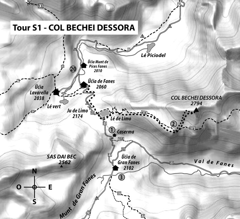

From Fanes Mountain Hut to Lé de Limo. Turn left (east) and take the well-marked path to Col Becchei Dessora (2565 m), where you can still see the remains of an artillery position from the First World War.
Then continue north on the path and then up some steep steps (sure-footedness is needed) to reach the top where you get a fantastic view. The descent is identical to the descent.
Duration: Ascent from 1½ to 2½ hours
Difference in altitude: around 750 m
Difficulty: not very difficult
Equipment: Mountain hiking equipment.
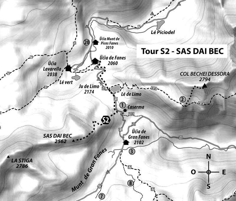

From the Fanes Mountain Hut to Lé de Limo almost up to the Italian barracks. To the right there is a trench that was used in battles during the First World War. These and other defensive positions around the barracks were assembly points for Italian troops who through Val de Fanes, the Furcia Rossa position and Ju dal’Ega (Tadega Pass) headed towards Munt de Gran Fanes.
A narrow and poorly maintained path starts in this trench that goes to the ridge. Further on the path continues to the right following the cairns in a south-westerly direction through a pasture to reach the summit. The descent is identical to the descent.
Duration: Ascent from 1½ to 2½ hours
Difference in altitude: around 500 m
Difficulty: low, requires a confident step and a good sense of direction
Equipment necessary: Mountain hiking equipment.
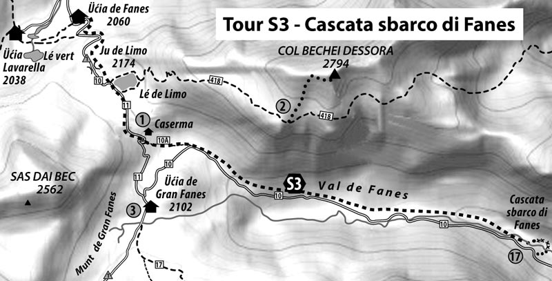

From the Fanes Mountain Hut take track number 11 to Ju de Limo, passing in front of the Italian barracks. Then take track number 10 and turn left just before the Gran Fanes Mountain Hut towards Val de Fanes. Continue on dirt track number 10 to an altitude of around 1720 metres above sea level. Just after there is a sign indicating the waterfall. It is possible to pass under the waterfall and continue for around 15 m along a path with ropes and return to the road after crossing over a small bridge. The way back is identical.
Duration: From 1 ½ to 2 hours
Ascent: around 110 m, descent around 450 m.
Difficulty: until the sign for the waterfall: not difficult
Until the waterfall: sure-footedness is necessary
Equipment: Mountain hiking equipment.
Along the via ferratas: We recommend you take personal safety equipment (for the via ferratas). Due to the humidity the rocks are rather slippery.
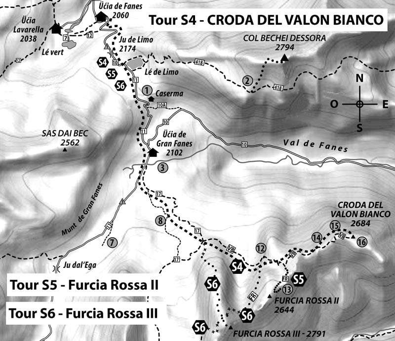

From the Fanes Mountain Hut (2060 m) to Ju de Limo (2172 m), continuing southwards to the Gran Fanes Mountain Hut and then continuing west towards Ju dal‘Ega. After around 300 metres the path turns south (sign »Via della Pace - Monte Valon Bianco«). Continue along this path until you reach the fork with the signpost.
Continue towards Monte Valon Bianco (VB) passing in front of the old »Deposito Rosso« no. 12 and the spring. Once you reach the crossroads with the walkway to Monte Valon Bianco (near the old cable car station Furcia Rossa 13) continue on to pass number 14. Climbing up the hairpin bends you reach a bridge then carry on to the old »Deposito Monte Valon Bianco« 15. From here turn right towards the summit along the Monte Valon Bianco summit plateau with the old artillery base no 16.
Duration: Ascent from 2 ½ to 3 ½ hours
Difference in altitude: around 720 m
Difficulty: not difficult but some parts of the path are very exposed, you need to be sure-footed and have a good head for heights.
Equipment: Mountain hiking equipment.


From the Fanes Mountain Hut like Tour S4 you continue to the fork at the northern foot of Furcia Rossa III. Then towards Valon Bianco (VB) near the old »Deposito rosso« no. 12 and passing in front of the rocky basin between Furcia Rossa I and Furcia Rossa II. Once you reach the fork in the road that goes to Monte Valon Bianco, go straight on to the old cable car station Furcia Rossa 13. Carry on in the rocky basin along the steep climb to the Baccon-Baborka 13 bivouac from where you can reach the summit of Furcia Rossa II in just a few minutes to the west.
Duration: Ascent from 2 ½ to 3 hours
Difference in altitude: around 740 m
Difficulty: not difficult
Equipment: Mountain hiking equipment.


The Furcia Rossa III peak can be reached from three different paths. All three are old war roads that are secured with ladders and wire rope systems. Ascent is only recommended for expert climbers with personal protection equipment. From the Fanes Mountain Hut like Tour S4 you continue to the fork at the northern foot of Furcia Rossa III.
- From the junction towards Valon Bianco VB and the »Deposito rosso« no. 12. At the »Brotzeitfelsen« (»the old restaurant«) with the small spring, turn right (sign FR) along the rocky ledge, climb the steps up to the junction with Furcia Rossa II and Furcia Rossa III. Then continue up the steps on the partially exposed path to ascend towards the summit from the back of the mountain to the south.
- At the junction head straight towards the western foot of Furcia Rossa III. Pass through a small gorge (steel wires) on easier terrain and on the northern rest of the mountain (FR sign) and then head towards the summit. This is the easiest way to reach Furcia Rossa III with some minor difficulty at the gorge at the beginning.
- At the junction keep right (path no. 17) to Monte Ciastel 9. Continue in a north-eastern direction and then go down the western side of Furcia Rossa III; climbing the steps you reach the easy side of the summit from the back and then the peak.
Duration: Ascent from 2 ½ to 3½ hours
Difference in altitude: around 820 m
Difficulty: The via ferratas is moderately difficult; we recommend you wear safety equipment
Equipment: Mountaineering equipment and normal via ferratas equipment (Furcia Rossa III).
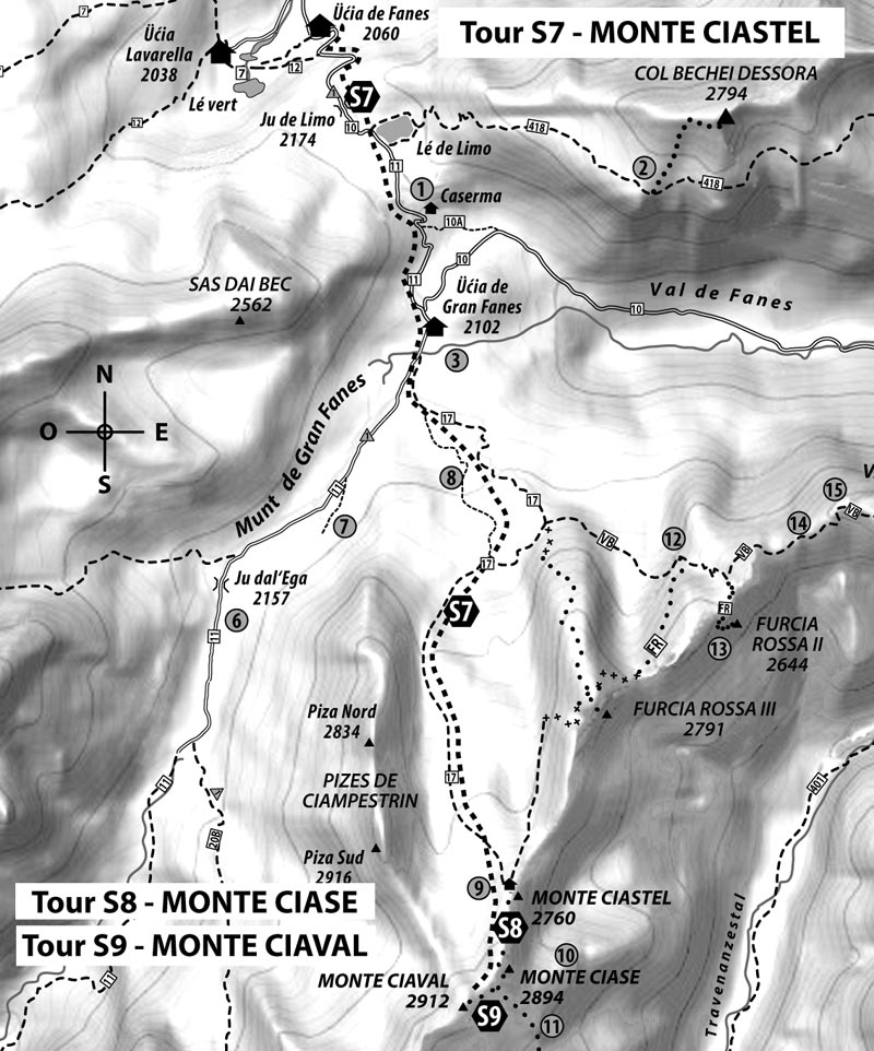

From the Fanes Mountain Hut (2060 m) like Tours S4, S5 and S6.
Take the direct path in Valun Blanch (partly in yellow and the sign Alta Via delle Dolomiti no. 1). Then you reach the former »Alpe Grande Central Station in Fanes« no. 8, the remains of which can be found to the left of the path.
Then pass through Valun Blanch next to the imposing Ciampestrin rock wall, you reach a steeper scree up to Monte Ciastel 9 which is now very visible at the foot of »Bivouac of Freedom«. It offers a great view of the Tofane Mountains and Val Travenanzes. The descent is the same as the ascent.
Duration: Ascent from 2 to 3 hours
Difference in altitude: around 790 m
Difficulty: not difficult
Equipment: Mountain hiking equipment.


Just like Tour S7 to Monte Ciastel and then continue on the path southwards under the peak of Monte Ciase. From the indicated route which turns left you can reach the summit in five minutes on the old war road which is now almost completely destroyed. Here you can find what is left of the old artillery base no 10. From the summit there is a spectacular view of Val Travenanzes.
The old »Outpost II« is still visible on the rocky ridge that stands out from the main ridge.
Duration: Ascent from 2 ½ to 3 hours
Difference in altitude: around 920 m
Difficulty: not difficult, you need to be sure-footed
Equipment: Mountain hiking equipment.


The same as Tour S8 you head towards Monte Ciase and then continue along the path until Forcela Ciasa. Here you can find the junction to the Alta Via delle Dolomiti (on which you can reach Val Travenanzes, along a difficult path which winds between rocky outcrops and screes. On the descent on this path you reach a rock formation (around 2590 m): some sources state that it is the so-called »Outpost I« 11 from the First World War).
From Forcela Ciase climb the hairpin bends up to the summit of Monte Ciaval in a few minutes.
Duration: Ascent from 2 ½ to 3 ½ hours
Difference in altitude: around 940 m
Difficulty: not difficult, you need to be sure-footed
Equipment: Mountain hiking equipment.
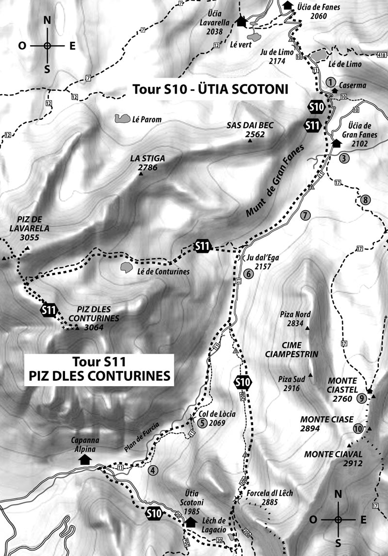

From the Fanes Mountain Hut along path number 11 passing through Ju de Limo up to the Gran Fanes Mountain Hut. Continue along the path until the old pioneer camp, passing in front of Le Gran Plan, then near the stream crossing on path number 20B up to Forcela dl Lêch. Climb the hairpin bends passing in front of Lake Lagaciò up to path number 20 along the stream to reach the Scotoni Mountain Hut.
Follow the access road that leads to the mountain hut until Capanna Alpina or by turning right on path number 11. The path leads to Col de Locia and returns to the Fanes Mountain Hut passing through Ju dal’Ega, the Gran Fanes Mountain Hut and Ju de Limo.
Duration: From 4 to 4 ½ hours up to the Scotoni Mountain Hut. The return via Capanna Alpina-Col de Locia around 4 - 4 ½ hours
Difference in altitude: Ascent and descent around 1000 m
Difficulty: not difficult, you need to be sure-footed
Equipment : Mountain hiking equipment.


From the Fanes Mountain Hut along path number 11 passing through Ju de Limo up to the Gran Fanes Mountain Hut and then towards Ju dal‘Ega (Tadega Pass/Tadegapass) just before you reach the pass where there is a small sign. From here turn left (south) to Piz dles döes Forceles (2929 m) up to the steep summit of Piz dles Conturines and the beginning of the via ferratas. With the help of steps and ropes you can reach the quite exposed summit and the wooden cross.
The descent is the same as the ascent. Alternatively you can ascend from Piz de Lavarela and then cross to Forcela de Medesc and descend by crossing the Pices Fanes plateau up to the mountain hut (see also Tour S12).
Duration: Piz dles Conturines: from 3 ½ to 4 ½ hours. Piz dles Conturines and Piz de Lavarela: from 5 ½ to 6 ½ hours
Difference in altitude: around 1,100 m and around 1,270 m
Difficulty: Very difficult, you need to be sure-footed and have a good head for heights
Equipment: Climbing equipment with a protective helmet in case of rock falls.
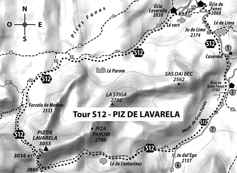

From the Fanes Mountain Hut along path number 11 passing through Ju de Limo up to the Gran Fanes Mountain Hut and then towards Ju dal‘Ega (Tadega Pass). Just before Tadega Pass the path bends westwards towards Büsc da Stlü (val Conturines). The path is indicated in red and white and winds along the wide, solitary valley then climbs up to the pass (2885 m). On the “Parco Fanes- Sennes- Braies” map the path is called “Trú Dolomieu”.
From there hairpin bends climb northwards along the scree to reach a slightly exposed rocky ledge and then finally up to a small plateau. Then climb northwards up a short but steep gully to reach a pass that separates the smaller peak (cross on the summit 3034 m) and the main peak (3055 m). Both are now accessible with a series of large crumbling stone steps that make it possible to reach the summit in a few minutes.
Duration: Ascent from 4-5 hours
Difference in altitude: 1100 m
Difficulty: medium, you need to be sure footed and have a head for heights.
Equipment: Mountain hiking equipment.
To descend take the same path as the ascent. It is also possible to descend on the north side but crossing the summit towards Forcella Medesc is not easy and is only recommended for experts.
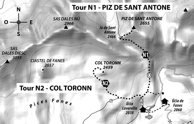

From the Fanes Mountain Hut go down to the bridge and then take path number 13 to the high plateau and then along the path that crosses the valley between Sas dles Nö and Piz de Sant Antone, up to Ju de Sant Antone (2466 m – also called Sant’ Antonio’s Pass). Then head northwards on the path that reaches the summit.
Duration: Ascent from 2-2 ½ hours
Difference in altitude: around 620 m
Difficulty: not difficult
Equipment: Mountain hiking equipment.


From the Fanes Mountain Hut follow path number 7 along the Pices Fanes high plateau and then without a path head in a north-westerly direction towards right or left climbing a very particular shaped mountain and reach the summit without any difficulty. An easy excursion.
Duration: Ascent from 1-1 ½ hours
Difference in altitude: around 420 m
Difficulty: not difficult but with poor visibility orientation is difficult
Equipment: Mountain hiking equipment.
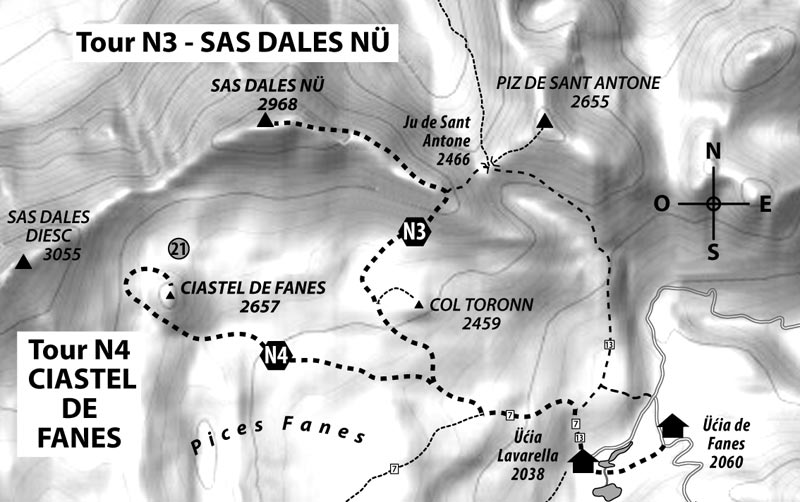

From the Fanes Mountain Hut along path number 13 to Ju de Sant Antone. Then keep left (indicated in red with cairns) continue along the path, part of which is on a simple via ferratas up to the ridge of Sas dles Nö.
Continue along the ridge up to the main peak along sections of the path secured with ropes.
Duration: Ascent 2 ½ - 3 hours
Difference in altitude: around 930 m
Difficulty: not difficult but there is no path or signs. With poor visibility orientation is difficult. Sure-footedness required.
Equipment: Mountaineering equipment, personal safety equipment for the parts secured with ropes.


Like Tour N3 proceed to the Pices Fanes plateau (path number 7). Continue along karst meadows until you reach Lé Sëch, at the foot of Ciastel de Fanes. Leaving them on your right and ascend the path up to the pass between Ciastel de Fanes and Sas dles Diesc (2605 m).
From here descending eastwards the so-called »prehistoric settlement« 21 can be reached in just a few minutes.
The tip of Ciastel de Fanes can be reached from the pass (also called »Burgstallscharte«), without a path and without any difficulty along the scree.
Note: Be careful of war remnants. Touching ammunition components can be dangerous!
Duration: Ascent from 2-3 hours
Difference in altitude: around 620 m
Difficulty: not difficult but with poor visibility orientation is difficult
Equipment: Mountain hiking equipment.
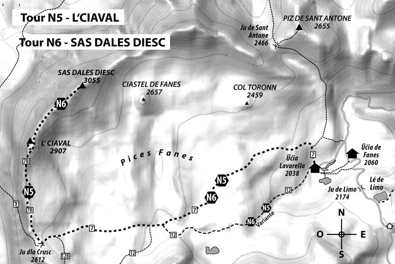


Just like Tour N5 for L‘Ciaval (Monte Cavallo). Just below the summit the trail branches off leading first to the pass between L’Ciaval and Sas dales Diesc and then continues along a scree up to the foot of Sas dales Diesc. More expert climbers can also reach the highest point of the summit with the cross by continuing along the via ferratas secured by ropes.
Duration: Ascent from 4-5 hours
Difference in altitude: around 1000 m
Difficulty: not difficult, the via ferratas up to the summit is moderately difficult (personal safety equipment is recommended!). Orientation is difficult when visibility is poor.
Equipment: Mountaineering equipment as well as personal safety equipment
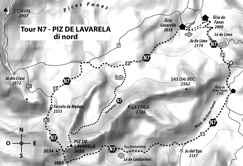

Ascent and scaling Piz de Lavarela from the north is long and demanding from a mountaineering point of view.
From the Fanes Mountain Hut; take the path to the Pices Fanes meadow at the crossroads of paths number 7 and 12 (2370 m). Continue along path number 12 towards Forcela de Medesc (Forcella Lavarella, 2584 m). Then follow the path southwards – at times difficult – up to the pass between the western peak (3034 m) and the main peak (3055 m).
Duration: Ascent from 3 ½ o 4 ½ hours. Difference in altitude: around 1000 m
Difficulty: difficult you need a good sense of direction, resistance and to be sure-footed.
Equipment: Mountaineering equipment and a protective helmet in case of rock falls.
The best descent is to the south towards the pass along the summer trail “Trú Dolomieu” (see tour S12).
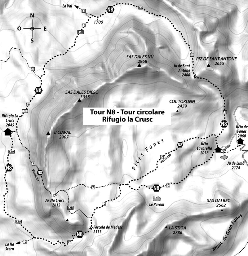

From the mountain hut in Pices Fanes meadow it is possible to do extremely interesting circular tours.
One of the most beautiful is around the rock formation of L‘Ciaval, Sas dles Diesc and Sas dles Nö. The tour can be done in both directions and is a very full whole day excursion and requires adequate resistance and strength. This long but particularly panoramic circular tour is particularly recommended in autumn in good weather.
From the Fanes Mountain Hut take trail number 13 to Ju de Sant Antone (2466 m) and continue up to an altitude of 1700 m along trail 15B to the left (south-west). Follow this path to the La Crusc Mountain Hut (Hospice of Santa Croce, 2045 m) with the Via Crucis.
From here, after a short ascent you can reach Pedraces with the chairlift.
From the La Crusc Mountain Hut there are two ways to continue the tour:
1. Continue along the path which is partially secured with 7 ropes until Ju dla Crusc S. Croce Pass, 2612 m). From there continue on path number 7 eastwards until the crossroads at an altitude of 2370 m above sea level. At this point it is possible to follow path number 7 that crosses Gran Ciamplac or keep right and take path number 12 that passes through Lé Parom and then onto the Fanes Mountain Hut.
Duration: from 10 to 12 hours
Effective distance: 19.4 km
Difference in altitude (ascent/descent): around 1760 m
Difficulty: For the most part not difficult. Secured path: difficult (personal safety equipment is recommended). You need a good sense of direction, resistance and to be sure-footed.
Equipment: Mountaineering equipment, protective clothing and a protective helmet in case of rock falls.
2. From the La Crusc 15 Mountain Hut (one of the stations on the Via Crucis) southwards without significant elevation up to crossroads 12A then turn south-eastwards. Follow this path to reach path number 12 in Val Medes that ascends to the Medesc Pass (2533 m). This path is more demanding and tiring given the light gravel (the ascent is easier than the descent).
Continue on path number 12 up the crossroads at an altitude of 2.370 m above sea level and then take path number 7 or keep right and follow path number 12 that leads to the Fanes Mountain Hut.
Duration: from 11 to 13 hours.
Effective distance: 21.9 km
Difference in altitude (ascent/descent): around 1670 m
Difficulty: not difficult, you need a good sense of direction, resistance and to be sure-footed.
Equipment : Mountain hiking equipment.
